by Dr J Floor Anthoni (2007)
www.seafriends.org.nz/issues/res/pk/ecology.htm
The Poor Knights islands are remnants of an
ancient volcano that eroded away long ago, leaving its hardest volcanic
plug behind. In this chapter we'll study and try to understand why things
are the way they are and how this influences underwater life. We'll also
look at the Poor Knights' terrestrial life.
geology: the ancient history left behind
in rocks and features. Ice ages.
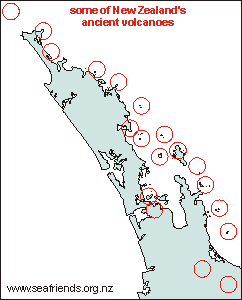
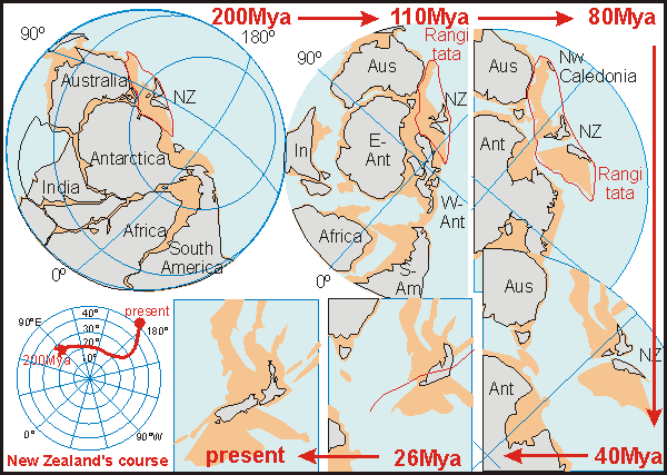
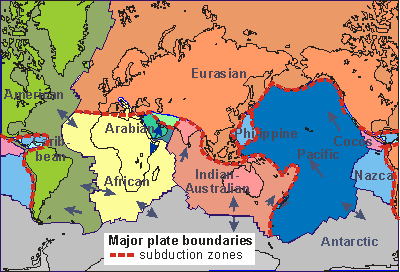
geology During
its 60 million year long separation from the ancient super continent Gondwana,
the two parts that would slide together (Rangitata continent) and join
to form present-day New Zealand, have been tearing apart from the Antarctic
Plate and colliding with the Pacific
Plate. When tectonic plates collide, the sea plate will slide under
the land plate, causing a trench while pushing the land up. This formed
Great Barrier Island and the Coromandel and Kaimai Ranges. In the process,
also volcanoes formed further inland. The map shows a number of ancient
volcanoes that form strings, each corresponding to crust fractures of another
period of geologic upheaval.
The most violent volcano New Zealand has known is by far Lake Taupo
(south-central outside the map). Rhyolitic volcanoes like this, contain
light molten rock (SiO2) with a lot of gas (CO2), and when they explode,
form clouds of ash. Later in their lives, the heavier rock emerges, with
less gas, until eventually the volcano cools down with the last and heaviest
rock remaining in its throat. This last plug, when cooled slowly, solidifies
to a hard volcanic rock that will last the ages.
It is thought that the Poor Knights too, were once (4 million years
ago) a rhyolitic volcano, producing a huge ash cone around, that connected
it to the mainland. Over time (a short time in fact), the ash cone was
eroded away by the sea, and the hard volcanic plug remained.
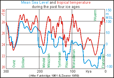
ice ages In
the past million years, the world has experienced a series of ice ages
with warm interglacials in-between. During the last ice age, which ended
about 8,000 years ago, the sea stood nearly 100 metres lower than today,
suggesting that the Poor Knights were again connected to the mainland.
But as soon as the waters began rising, some 25,000 years ago, it became
isolated again. So the flora and fauna on the Poor Knights have been living
in isolation for no more than 25,000 years, which is enough to cause some
diversification. The graph shows a possible history of the sea level in
the past 300,000 years, revealing that also for a long period of time,
the Poor Knights were entirely below sea level.
The Poor Knights has many geological features such as caves, archways
and undersea terraces. Knowing that sea waves can cause serious erosion,
it is all too easy to assume that the sea has carved these. An underwater
terrace can be explained by sea erosion (a beach) when the sea stood at
that level. But the sea stood at various levels for prolonged times, and
we do not observe that many terraces. Is an archway caused by sea erosion,
but when? In the past 6000 years, 100,000 years ago, or a million years
ago?
A sea cave must surely have been caused by sea erosion, but this cannot
explain Rikoriko which has a smooth ceiling from which no 'bricks' are
missing. Neither can it explain Red Baron caves' vertical tunnels, and
it can't explain Taravana cave at the Knights' sheltered side, at all.
Obviously a volcanic plug is full of cavities where once gases were. Tunnels
guided liquid lava from a spewing mouth, then emptied out while lava flowed
downhill, leaving a vacated tunnel behind. Look at South
Harbour for instance. See how all the archways and passages are pointing
outward from an imaginary centre? This cannot be explained from sea erosion.
biogeography Biogeography is the science that links life (bios) with where it lives
(geography). So it provides a way of looking at the bigger picture, in
particular temperature, currents and waves. On this web site you'll find
a large chapter on oceanography
that paints the worldwide picture, of which this chapter is a small addition.
circulation Because
the tropics are warm and the poles cold, winds flow to equalise this difference.
But the rotation of Earth deflects their path, resulting in climate bands
that dominate rainfall and wind. As winds blow over the sea, they get a
grip on its surface and push it along. A surface current results. The places
where winds blow consistently in the same direction, create permanent currents
that contribute to large ocean gyres. The largest of these is the South
Pacific gyre, as shown in this diagram. The currents of the gyre also transport
heat from the tropics to the poles and cold from the poles to the tropics.
For New Zealand the warm Coral Sea current is of critical importance since
it contributes at least 2ºC to temperature.
temperatures From
the Pacific Gyre, the temperature distribution shown here, can now be understood.
The green band shows how subtropical water is pushed towards the equator,
along the coast of Peru, where it bathes the Galapagos Islands' water in
much the same temperature as northern New Zealand (because the sea warms
up slowly). Notice that the western side of this large gyre does not show
an equally pronounced red plume descending along eastern Australia's coast
(because heat escapes quickly), but the green band reaches south to Tasmania.
Note that these bands move up and down with the seasons, and also that
the Pacific Gyre is sometimes stronger than in other years. When this happens,
northern New Zealand becomes noticeably warmer, particularly its sea.
If we had to give names to the arbitrary 'false colour' scheme, it
would be as follows: red= warm tropical, yellow=cool-tropical, green=subtropical,
cyan=temperate, blue=subantarctic (subpolar), magenta=antarctic (polar).
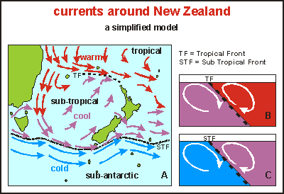
currents around New Zealand The
diagram shows how currents flow around New Zealand. Warm tropical water
drifts southward along Australia's east coast in the East Australian Current
(EAC) where it splits into two currents. The warm water flows eastward
along the tropical front, brushes past the Poor Knights and veers off into
the Pacific Ocean. A front in the sea is formed when warm water meets cold
water (Tropical Front, TF). Because the warm water wants to lay on top
of the cold water, the two won't mix, and a virtual wall between the two
is formed, with vertical upwellings and down drafts, and horizontal eddies.
It is a place of high productivity.
The remaining water flows towards Tasmania where it leaves the coast,
colliding with sub-antarctic cold water along the SubTropical Front (STF).
The cool (purple arrows) and the cold (blue arrows) water with their associated
upwellings, pass east of the South Island where it feeds the seal colonies
and sea birds. The two then veer off eastward into the Pacific.
Some of the cool (purple arrow) water passes along NZ's west coast,
to collide with the Tropical Front, pushing around North Cape and sliding
under the warmer water. This slow current passes along all the dirt of
the North Island's big rivers, and all the sewage from Auckland and Hamilton,
and the cows in the Waikato, that all deposit nutrients in the sea. The
sea becomes overfertilised and sick, which we measured and confirmed (DDA).
This sick sea curves around North Cape to plague the waters of Northland,
including the Poor Knights.
In years when the ocean currents flow fast (La Niña), our coasts
are rinsed better than in those years when the currents stagnate (El Niño).
This happens in a cycle of about 9 years, with 1983, 1992, 2001 the years
of mass mortalities. See degradation
timeline.
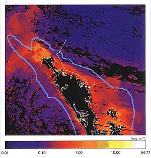
nutrients Nutrients
in the sea are important to sea life and the life that depends on it, like
dolphins and humans. The map here was generated from satellite information
measuring the chlorophyll (green plant matter) densities. It is a complicated
scientific process that has a number of limitations, like not being able
to distinguish between brown mud and brown plankton, and looking only at
the first few metres of depth, and it being a snapshot in time. But what
it shows is telling enough. Notice that the scale is logarithmic, portraying
a density range of 1000x (0.01-10.0). Small colour differences thus mean
large quantitative differences.
The rich nutrient flow of the west coast is hidden by clearer water
overlaying the dirtier coastal water. Remember that this coast has almost
constant westerly winds and waves. The nutrient-rich water surfaces between
North Cape and the Three Kings islands, joining the natural upwellings
of the Tropical Front. It then bends around the Cape, flowing south under
another blanket of warmer water, but it surfaces here and there. Notice
how the nutrients stay concentrated over the continental shelf (light blue
contour). Notice also how nutrient-laden water exits from the Hauraki Gulf
northward and eastward, and that a clearer body of water stretches between
Whangarei and Mokohinau.
As you can see, the Poor Knights appear to be threatened by eutrophied
waters from the west coast. Our measurements indeed support this. In due
time all sea life will be affected, like fish, gannets, shags, shearwaters
and dolphins. This in turn could influence the terrestrial life.
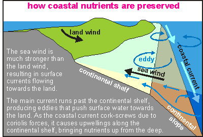
continental shelf edge The
Poor Knights are located at the edge of the continental shelf, which is
depicted in this diagram. One would think that the continental shelf empties
out into the open ocean, through wind-driven currents and ocean currents,
but there are forces at work to keep nutrients over the productive shallows
of the continental shelf. The mainland makes an enormous difference to
the strength of the waves and surface currents, with the result that the
sea wind has a far stronger effect than the land wind, thus mopping nutrients
back onto the shelf, and also larvae back to the shore. The coastal current
(East Auckland Current) which runs effectively at 50-100m depth, runs further
out in sea, and as it clings to the land, it rotates in such a way that
deep nutrients are pushed back to the surface, and onto the shelf. Finally,
eddies splitting off the coastal current, gyrate nutrients back.
From this scenario one can now understand that the Poor Knights are
on the one hand under the influence of a unidirectional ocean current that
connects it to warmer places like Australia, Norfolk Island and Lord Howe
Island. On the other hand it experiences eddies, that can at times be very
strong, whipping currents where one would not expect them (like in Labrid
Channel). It can now also be understood that the larvae produced by the
creatures at the Poor Knights, find their way downstream and to the mainland,
but there is no strong mechanism to take larvae back out to the islands.
Thus recruitment is weak.
The other main factor is that the islands are located close to natural
upwellings that result in high productivity and high fish densities. However,
in recent times, this has been changing, and we think because polluted
west coast water is now reaching the islands.
tides In New Zealand the moon tide runs as a long wave around both the south
and the north island twice each day. It is a deep and fast wave (see oceanography/tides).
Where this tide wave becomes distorted, such as when entering a harbour
like the Hauraki Gulf, the wave becomes distorted, resulting in tidal currents.
But out in the open ocean, when folding around a remote island in a deep
sea, it generates hardly any tidal currents. The Poor Knights are not exactly
such a remote island, but tidal currents are not as fierce as found nearer
to the coast. Even so, the moon tide causes currents that may work in unison
with coastal currents and eddies, and cause unpredictable surprises.
marine ecology Perhaps the most important factor to consider is that the Poor Knights
islands are long and narrow, orientated in a north-south direction, in
parallel with the mainland, and across the direction of the main wave action
(NE). This makes its easterly side decidedly exposed to wave action, but
its westerly side sheltered from damaging hurricanes. It acts like a barrier
island.
On the east side we'll find rugged seaweeds and other rugged organisms,
whereas on its west side sensitive ones. Combined, the two environments
lead to a higher than normal biodiversity. In addition there are archways
that can on the one hand exacerbate (make worse) wave action (Barren Arch),
and on the other hand provide shelter (Middle Arch, Northern Arch, The
Tunnel).
This north-south orientation achieves that both sides receive an almost
equal amount of sunlight, but south-facing shores receive significantly
less sunlight, also because the cliffs are so high that the sun cannot
peep over them (Sombre Forest, Rocklilly Bay, see further down).
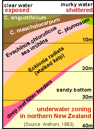
habitat zoning This
diagram shows the general idea behind underwater habitat zoning in northern
New Zealand, but there are differences that apply to the Poor Knights.
For instance, because near the surface, all its shores drop off vertically,
except in a few places. So the intertidal zone is also narrow, except on
its eastern side where waves wet a wide splash zone with barnacles and
encrusting seaweeds.
Directly on and under low tide one finds robust stringy seaweeds or
bladder wracks, of which the golden wrack (wire weed, Carpophyllum angustifolium)
is the toughest. On some places of the east side, it competes with the
ultra tough bullkelp (Durvillea antarctica), which underlines the
connection with the west coast and the South Island where it dominates.
Below the stringy seaweeds comes the barren zone, caused by storms
but often occupied by sea urchins. Because the eastern shores here are
so steep and exposed, urchins cannot maintain themselves there, and the
barren zone is populated by turfing calcareous algae.
Below the barren zone extends the stalked kelp forest (Ecklonia
radiata), which eventually gives way to the deep reef of animal rock
dwellers like sponges, gorgoneans and bryozoans.
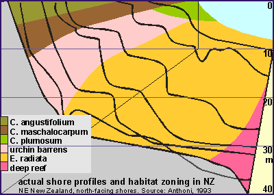
These two habitat zoning diagrams were measured by us in
1993,
and apply only to north-facing shores. We were able to do so once we discovered
that the depth of the sandy bottom is a measure of the strength of the
worst waves. On left the general pattern, showing the zoning with species
names, and on right a number of typical shore profiles were also included.
It is important to notice that as wave exposure increases (towards the
foreground), the shore becomes steeper and steeper as a reaction to minimise
biotic and material losses (erosion). See our Least
Loss Landscape hypothesis. Steep shores reflect the waves, such that
minimal energy is absorbed. Notice also the spontaneous terracing, probably
caused by plant life as plants promote terracing. For the Poor Knights
the 30m terrace is indeed present on its west side.
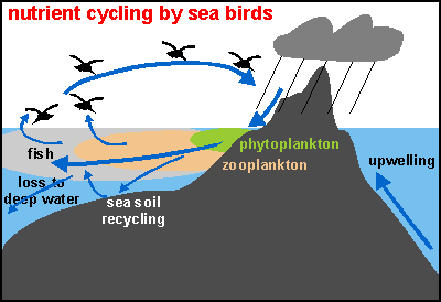
nutrient cycling by birds On
truly remote islands like the Kermadec Islands, the influence of seabirds
on the marine environment cannot be overstated. The diagram shows how it
works. Birds nest in their millions on the island, and deposit half of
their meal on the rocks or in their burrows. These bird droppings are extremely
high in nutrients, and should they consolidate and harden, would become
the most sought after guano fertiliser.
However, before that happens, rains dissolve some of the nutrients
and surround the islands in a slick of nutrients that almost immediately
turns into phytoplankton. Hours later the zooplankton will be feasting
on it, and the food chain is closed by bait fish, and sea birds.
However, in the meantime the slick of productivity has spread out wide
and deep, and is drifting away on ocean currents. Fortunately the birds
recycle a good part back onto the land. How much is not known, but it can
be observed at the Knights after a rain.
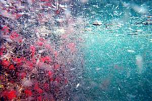
One day I happened to snorkel near Northern Arch, Catton's Cave when
I noticed small streams seeping down the rock face and colouring the sea
surface yellow - a kind of pee. As I continued downstream, I noticed that
this pee was turning green. The gentle current was taking the slick southward,
clinging to the shore, perhaps 10m wide, becoming wider and deeper. It
was amazing to see how little pee could generate so much green soup. Then
little dots began to appear and the little dots became shrimps. That's
where it ended for me, except that I took the boat to Jan's Tunnel at the
southern end of the islands.
The slick had arrived here and like a continuous conveyor belt, had been
going on for days, perhaps. In the tunnel the shrimps were so dense that
one could hardly see. The red horse anemones (Isactinia tenebrosa)
were having their day, many closed up for they were full. The shrimp were
moulting, as transparent moults glared in the sunlight. Since the plankton-feeding
fish had missed this event, the shrimps were even mating and dying. At
the bottom a Porae quietly mopped up the fallen shrimps as if it always
did this. What an awesome experience.
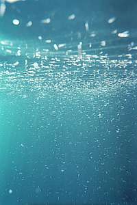
f012023: the thin slick of yellow pee has turned into green
phytoplankton soup, while also spreading wider and deeper.
f012033: little white dots became agile shrimps, feasting
on the phytoplankton.
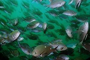
f012014: in the meantime blue maomao were busy somewhere
else, not aware of the coming party.
f012035: at Jan's Tunnel the zooplankton had become a riot,
shrimps moulting and procreating and dying too. The red blobs are horse
anemones sharing in the feast.
f012037: as spent shrimps sank to the bottom, a porae was
waiting for them, casually slurping them from the bottom.
The fact that the semi-pelagic fish schools did not notice this not
so unusual event, may be explained by them not being hungry or by them
being unobservant, but these fish know very well what is going on in the
sea. Scientists have measured that the zooplankton upstream from the Knights
is very much denser than that downstream of it. So the many planktivores
(plankton pickers) do a very good job of depleting this resource. For this
reason, being upstream rather than downstream, gives them an important
gain in competing for the stuff. So, the general idea they have is that
upstream=food. The yellow pee slick described before, however, equates
to downstream=food, thereby complicating the issue.
Thus the current = coastal current + tidal current, plays an important
role to their daily rhythms. When the current stops, it is time to rest
(in shelter) and to digest (in shallow warm water). Hence their many daily
migrations to and from shallow caves, to and from promontories. The demoiselles
also migrate to and from spawning spots, guarded by males. So they are
the busiest fish of all.
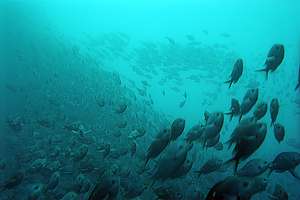
I spent days following the streams of migrating demoiselles to understand
what they were up to, and surprise? They actually also migrate the whole
length of both islands, when the current changes! It seems a waste of energy,
but for them it is apparently worth it. So, each time that you see these
small fish rowing busily with their breast fins, think about how effective
their way of swimming really is and how busy their lives.
f040617: close-up of migrating two-spot demoiselles Chromis
dispilus. Green ones are females, blue ones males. These are young
fish.
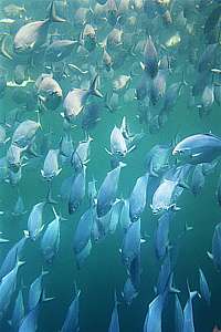
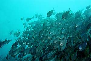
f021125: a serious migration scene, showing thousands of
demoiselles with a single purpose.
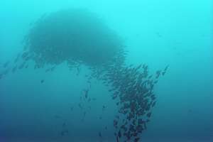
f021126: demoiselles gather in tight formation to collectively
ascend into the current.
.
f021122: while slowly degassing their float bladders, demoiselles
together make the slow ascent up into the current and away from the sheltering
rocks.
the sand Significant sandy areas are not likely to be found around remote pinnacles,
one would think. But the reality is that the Poor Knights have a sustainable
quantity of it. One would think that waves would soon wash all sand into
the deep, but it is staying in some places. What's going on?
The
sand habitat is home to a great variety of organisms, most hidden in between
the sand grains, or burrowed out of sight. Divers will notice that the
sandy areas are never devoid of fishes. On the contrary, one finds quite
a lot going on. Wrasses nip and turn the sand to find morsels of food,
goatfish stir the sand with their barbels, lizardfishes and scorpionfishes
lay there in ambush, hat urchins crawl over it and stingrays come to rest
there, and so on.
The sand we know from white beaches consists almost exclusively of silica
(SiO2), which is formed when rock weathers under a forest, as soil is formed
(see enviro/soil). It does
not result from bare rock breaking into small pieces. The silica sand may
be a million years old, having been there for many ice ages and interglacial
like today. When examining the sand around the Poor Knights, one will see
that it is high in silica but also contains limestone remains of shelled
organisms, from snails to bryozoans. These gather at the bottom of cliff
faces.
Sand is of course found only on flat bits of rock, and the larger these
flat areas, the more significant the sandy habitat becomes. Between Serpent
Rock and Rikoriko extends a slightly sloping flat area, often thought of
as an ancient sunken beach, which may not be true. It could well
have been a large terrace maintained by forest vegetation during the ice
ages. The forest would explain the amount of silica found. The other significant
sandy area is found from Ngaio Rock through Labrid Channel to South Harbour.
This too is best explained as a forest terrace during ice ages.
Another large terrace is found in Bartle's Bay, but its sand is stirred
by large storm waves and transported through the gap between the two main
islands, where it contributes to the Sand Garden. Westerly waves are just
strong enough to mop sand back onto the Sand Garden, to a depth of about
30m. Any sand below this margin slips into the deep.
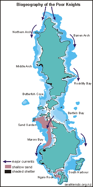
In the biogeography map shown here, the major influences on the marine
environment are shown, the shallow sand, the major current points for pelagic
fish and the shaded walls that also have a high degree of shelter. Note
that the east side has only one wall, which is semi-sheltered because it
is steep and deep, bouncing waves back into sea, without absorbing their
energy. It is also 'around the corner' for the worst waves from the north-east
terrestrial ecology Maori inhabitation of the island has changed the original environment
in the following ways:
clearing the forest for pa sites (villages) and horticulture, the culture
of sweet potato (kumara)
terracing for horticulture and inhabitation. Stone walls.
use of the forest timber for canoes, palisades (stockades) and cooking.
All mature forest trees have been used, followed by the importation of
timber from the mainland. The native totara tree was used for making canoes.
pigs have been introduced and left to roam wild, with serious consequences
for the native wildlife.
Since the islands were abandoned and later declared a sanctuary, the wild
pigs have been removed (1936), and native flora and fauna left to recover.
The present vegetation is largely secondary forest that is regenerating:
pohutukawa (Metrosideros excelsa) on the seaward slopes, pohutukawa
and kanuka (Kunzea ericoides) on the inland plateaus and kohekohe
(Dysoxylum spectabile), tawapou (Beilschmidia tawa) and karaka
(Corynocarpus laevigatus) in gullies. Ngaio (Myoporum laetum),
taupata (), karo (Pittosporum crassifolium), mahoe (Melicytus
ramiflorus), coastal karamu (), Poor Knight's mapou (Myrsine australis)
and Poor Knight's kawakawa (Macropiper excelsium) form a tight scrub
where the exposure to salt winds is the greatest. (Salt spray kills leaves,
and by staying small and growing a tight low bush, the vegetation can survive)
Because the islands have been isolated for a relatively short time (tens
of thousands of years), the wildlife there is still very much the same
as that found on the northern part of the North Island, with the following
exceptions:
the beautiful Poor Knight lily () with its extravagant sprays of red flowers,
is abundant and occurs no where else except one, a rarity on the Hen Island
of the Hen and Chicken Islands.
the Poor Knight mapou and Poor Knight's houhere which differ from their
mainland relatives.
the Poor Knight kawakawa has become quite distinct from mainland varieties
Other coastal natives found on the island include: kohekohe, tawapou, karaka,
ngaio, taupata, karo, mahoe and karamu, all normal trees and shrubs of
a mainland coastal forest. coastal astelias (a tree epiphyte, kowharawhara,
Astelia banksii), rock lilies (rengarenga, Arthropodium cirratum),
flax (harakeke, Phormium tenax) and toetoe (a tall coastal grass,
Cortaderia splendens) cling to rocky outcrops and inland cliffs.
sea birds No less than nine species of petrel (flesh-footed shearwater Puffinus
carneipes, sooty shearwater P. griseus, fluttering shearwater
P. gavia, fairy prion Pachyptila turtur, grey-faced petrel
Pterodroma macroptera, Pycroft's petrel Pterodroma pycrofti,
white faced storm petrel Pelagodroma marina, diving petrel Pelecanoides
urinatrix) flock to the islands to breed between October and May. Late
at night one can hear them coming home in their thousands, shouting to
one another while flying fast in the dark, criss-crossing one another's
paths. Then they mysteriously dive into the dark vegetation, to land precisely
on the spot where their burrows are found and their chicks are waiting.
In late summer one comes across large swaths of water with young birds
'parked', awaiting for the return of their parents. And every time, these
parents flawlessly home in on their chicks' cries, even in pitch darkness.
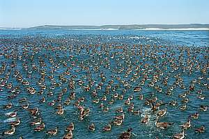
About 2.5 million Buller shearwaters (rako, Puffinus bulleri)
breed only on the Poor Knights, to which they return from their journeys
to outlying islands, the Chatham Islands and even from as far as California!
Researchers have noticed that these birds show no fear of Man, and when
they accidentally land on a ship's deck, they can be handled without fear
or aggression. The young birds (rako) are a prized delicacy by the tribes
who occupied the islands, and who cooked and rendered them in their own
fat, then stored them in hollow bullkelp fronds, and left to dry. The Maori
also mastered the preservative method of smoking, for which the wood of
manuka and kanuka was preferred.
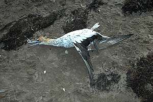
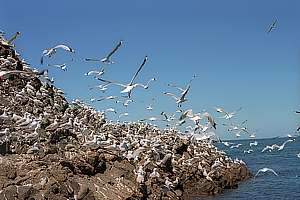
Australasian gannets (takapu, Morus serrator) nest on the Poor
Squires Islands (the Sugarloaf and the Pinnacles) in their thousands. From
this strategic, inaccessible fortress they swarm out in small groups over
distances exceeding 200km, effortlessly going out in the morning and returning
by night. Seeing streams of these large birds flying low over the water,
is quite impressive. Their flight consists of a few wing flaps, followed
by a glide.
Gannets fish by diving from 20-40 metres height, while holding their
wings streamlined alongside their bodies. As they shoot down to 3-5m depth,
they steer with their wings, while using their long necks and beaks to
catch their prey. It is a surprisingly efficient method, perfected by diving
into their own shadow, arriving from the blinding sun. Another strategy
is flying low over the water and diving at a low angle into a previously
scouted patch. A gannet does not dive for a single fish, but aims for a
few from the air, and once in the water, makes a fast decision.
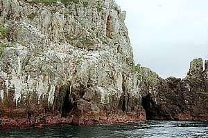
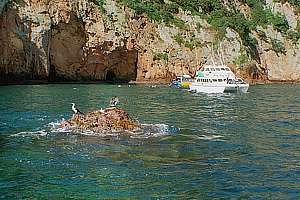
The Poor Knights also has a resident colony of pied shags (karuhiruhi,
Phalacrocorax varius) that can usually be found in trees above The
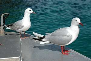
Gardens, or drying their feathers on a low rock. Red-billed gulls (Larus
novaezealandiae, tarapunga) used to be common, gathering over surface-feeding
schools of fish.
Other sea birds encountered are white fronted terns (tara, Sterna
striatis) and little blue penguins (korora, Eudyptula minor).
f219022: Buller shearwaters (Puffinus bulleri) in
their thousands waiting for the wind to pick up. These storm birds glide
effortlessly on the uplift from waves, shearing the waves so close that
their wings tip the water.
f218819: a gannet colony on Sugarloaf Island. Males arrive
first at the end of July to prepare the nest site they occupied the year
before. Gannets mate for life. Young birds return to the colony after
two to five years to find a mate and continue the cycle.
0710157: although gannets (Morus serrator) can grow
old, they live a precarious life that demands food every day. A single
storm preventing them from feeding, can result in many dead or emaciated
birds that wash up on a beach.
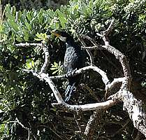
f030504: pied shags drying their feathers on a pinnacle in
The Gardens. Shags are such good free-divers because their feathers become
wet, no longer holding trapped air. After their dives they cannot fly very
well, preferring low rocks for drying up, after which they are able to
fly to their higher roosts.
0612107: a young pied shag (karuhiruhi, Phalacrocorax
varius) had lost its bearings and overnighted in a shed. It has just
moulted but does not have adult plumage showing a white crop. Also its
cheeks are still yellow.
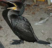
0701120: the little shag (kawaupaka, Phalacrocorax melanoleucos)
is always very shy. It has a rough crest. Here it is drying its feathers
in a sheltered tree above South Harbour. Notice its much smaller beak.
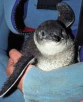
f015332: a fledging blue penguin (Eudyptula minor)
about to lose its nest down. This variety is white under its flippers.
Blue penguins live a harsh life, swimming long distances each day.
0701113: red-billed gulls (Larus novaehollandiae):
a mature one in the foreground and a young one behind. The young one does
not have red feet and bill yet, and its plumage is speckled.
f218937: red-billed gulls used to be very numerous on Serpent
Rock, but their numbers have dwindled considerably.
land birds The main resident land birds on the main islands are bellbirds (korimako,
Anthornis melanura) and red- crowned parakeets (karaiki, Cyanoramphus
novaezelandiae). Fantails (piwakawaka, Rhipidura fuliginosa)
are found in small numbers while kingfishers (kotare, Halcyon sancta),
pipits (pihoihoi, Anthus novaeseelandiae) and harriers (kahu, Circus
approximans) are often seen. The elegant, dark-slated spotless crake
(putoto, Porzana tabuensis) and banded rail (mohopereru, Rallus
philippensis), both swamp birds, forage on the forest floor. Summer
visitors are the long-tailed cuckoo (koekoea, Eudynamys taitensis)
and shining cuckoo (pipiwharauroa, Chrysococcyx lucidus).
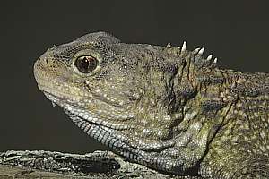
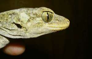
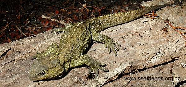
reptiles and insects The islands have a wide variety of insect and reptile life. Tuatara
(Sphenodon punctatus) are found on the larger islands, along with
two species of gecko and five species of skink. Duvaucel's gecko (Hoplodactylus
duvauceli), New Zealand's largest gecko is well established and can
reach 30 cm in length. During the day it hides in the caves and crevices
or under bark and stones, venturing forth at night time in search of berries,
nectar and insects.
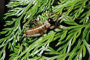
A giant centipede is found on Aorangi Island, as well as the flax snail
with a long spiral shell, and several species of weevil. Probably the most
frightening of the inhabitants of the islands are the giant tree weta,
growing up to 8cm and the giant cave weta. This latter insect has a body
about 6cm long but measures 30 cm from the top of its antennae to the claws
on its hind legs and can weigh about 40gm.
05061131: close-up of tuatara (Sphenodon punctatus).
Duvaucel's Gecko (Hoplodactylus duvauceli).
05061138: an almost mature tuatara (Sphenodon punctatus)
on a wooden log. A tutatara is a heavy lizard, that feels icy cold when
held. They can grow very old and reproduce erratically. (www.reptilepark.co.nz)
0704277: a young tree weta (putangatanga, Hemideina thoracica)
has formidable jaws.
 During
its 60 million year long separation from the ancient super continent Gondwana,
the two parts that would slide together (Rangitata continent) and join
to form present-day New Zealand, have been tearing apart from the Antarctic
Plate and colliding with the Pacific
Plate. When tectonic plates collide, the sea plate will slide under
the land plate, causing a trench while pushing the land up. This formed
Great Barrier Island and the Coromandel and Kaimai Ranges. In the process,
also volcanoes formed further inland. The map shows a number of ancient
volcanoes that form strings, each corresponding to crust fractures of another
period of geologic upheaval.
During
its 60 million year long separation from the ancient super continent Gondwana,
the two parts that would slide together (Rangitata continent) and join
to form present-day New Zealand, have been tearing apart from the Antarctic
Plate and colliding with the Pacific
Plate. When tectonic plates collide, the sea plate will slide under
the land plate, causing a trench while pushing the land up. This formed
Great Barrier Island and the Coromandel and Kaimai Ranges. In the process,
also volcanoes formed further inland. The map shows a number of ancient
volcanoes that form strings, each corresponding to crust fractures of another
period of geologic upheaval.
 In
the past million years, the world has experienced a series of ice ages
with warm interglacials in-between. During the last ice age, which ended
about 8,000 years ago, the sea stood nearly 100 metres lower than today,
suggesting that the Poor Knights were again connected to the mainland.
But as soon as the waters began rising, some 25,000 years ago, it became
isolated again. So the flora and fauna on the Poor Knights have been living
in isolation for no more than 25,000 years, which is enough to cause some
diversification. The graph shows a possible history of the sea level in
the past 300,000 years, revealing that also for a long period of time,
the Poor Knights were entirely below sea level.
In
the past million years, the world has experienced a series of ice ages
with warm interglacials in-between. During the last ice age, which ended
about 8,000 years ago, the sea stood nearly 100 metres lower than today,
suggesting that the Poor Knights were again connected to the mainland.
But as soon as the waters began rising, some 25,000 years ago, it became
isolated again. So the flora and fauna on the Poor Knights have been living
in isolation for no more than 25,000 years, which is enough to cause some
diversification. The graph shows a possible history of the sea level in
the past 300,000 years, revealing that also for a long period of time,
the Poor Knights were entirely below sea level.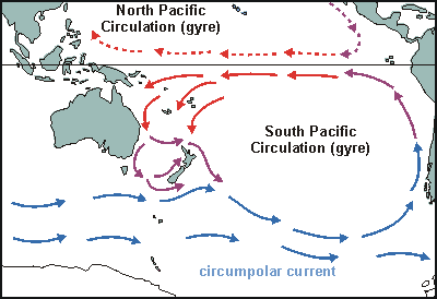 Because
the tropics are warm and the poles cold, winds flow to equalise this difference.
But the rotation of Earth deflects their path, resulting in climate bands
that dominate rainfall and wind. As winds blow over the sea, they get a
grip on its surface and push it along. A surface current results. The places
where winds blow consistently in the same direction, create permanent currents
that contribute to large ocean gyres. The largest of these is the South
Pacific gyre, as shown in this diagram. The currents of the gyre also transport
heat from the tropics to the poles and cold from the poles to the tropics.
For New Zealand the warm Coral Sea current is of critical importance since
it contributes at least 2ºC to temperature.
Because
the tropics are warm and the poles cold, winds flow to equalise this difference.
But the rotation of Earth deflects their path, resulting in climate bands
that dominate rainfall and wind. As winds blow over the sea, they get a
grip on its surface and push it along. A surface current results. The places
where winds blow consistently in the same direction, create permanent currents
that contribute to large ocean gyres. The largest of these is the South
Pacific gyre, as shown in this diagram. The currents of the gyre also transport
heat from the tropics to the poles and cold from the poles to the tropics.
For New Zealand the warm Coral Sea current is of critical importance since
it contributes at least 2ºC to temperature.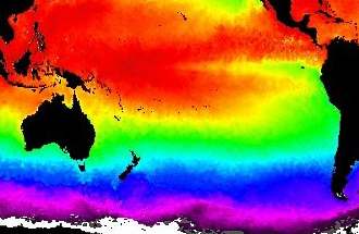 From
the Pacific Gyre, the temperature distribution shown here, can now be understood.
The green band shows how subtropical water is pushed towards the equator,
along the coast of Peru, where it bathes the Galapagos Islands' water in
much the same temperature as northern New Zealand (because the sea warms
up slowly). Notice that the western side of this large gyre does not show
an equally pronounced red plume descending along eastern Australia's coast
(because heat escapes quickly), but the green band reaches south to Tasmania.
Note that these bands move up and down with the seasons, and also that
the Pacific Gyre is sometimes stronger than in other years. When this happens,
northern New Zealand becomes noticeably warmer, particularly its sea.
From
the Pacific Gyre, the temperature distribution shown here, can now be understood.
The green band shows how subtropical water is pushed towards the equator,
along the coast of Peru, where it bathes the Galapagos Islands' water in
much the same temperature as northern New Zealand (because the sea warms
up slowly). Notice that the western side of this large gyre does not show
an equally pronounced red plume descending along eastern Australia's coast
(because heat escapes quickly), but the green band reaches south to Tasmania.
Note that these bands move up and down with the seasons, and also that
the Pacific Gyre is sometimes stronger than in other years. When this happens,
northern New Zealand becomes noticeably warmer, particularly its sea.
 The
diagram shows how currents flow around New Zealand. Warm tropical water
drifts southward along Australia's east coast in the East Australian Current
(EAC) where it splits into two currents. The warm water flows eastward
along the tropical front, brushes past the Poor Knights and veers off into
the Pacific Ocean. A front in the sea is formed when warm water meets cold
water (Tropical Front, TF). Because the warm water wants to lay on top
of the cold water, the two won't mix, and a virtual wall between the two
is formed, with vertical upwellings and down drafts, and horizontal eddies.
It is a place of high productivity.
The
diagram shows how currents flow around New Zealand. Warm tropical water
drifts southward along Australia's east coast in the East Australian Current
(EAC) where it splits into two currents. The warm water flows eastward
along the tropical front, brushes past the Poor Knights and veers off into
the Pacific Ocean. A front in the sea is formed when warm water meets cold
water (Tropical Front, TF). Because the warm water wants to lay on top
of the cold water, the two won't mix, and a virtual wall between the two
is formed, with vertical upwellings and down drafts, and horizontal eddies.
It is a place of high productivity.
 Nutrients
in the sea are important to sea life and the life that depends on it, like
dolphins and humans. The map here was generated from satellite information
measuring the chlorophyll (green plant matter) densities. It is a complicated
scientific process that has a number of limitations, like not being able
to distinguish between brown mud and brown plankton, and looking only at
the first few metres of depth, and it being a snapshot in time. But what
it shows is telling enough. Notice that the scale is logarithmic, portraying
a density range of 1000x (0.01-10.0). Small colour differences thus mean
large quantitative differences.
Nutrients
in the sea are important to sea life and the life that depends on it, like
dolphins and humans. The map here was generated from satellite information
measuring the chlorophyll (green plant matter) densities. It is a complicated
scientific process that has a number of limitations, like not being able
to distinguish between brown mud and brown plankton, and looking only at
the first few metres of depth, and it being a snapshot in time. But what
it shows is telling enough. Notice that the scale is logarithmic, portraying
a density range of 1000x (0.01-10.0). Small colour differences thus mean
large quantitative differences.
 The
Poor Knights are located at the edge of the continental shelf, which is
depicted in this diagram. One would think that the continental shelf empties
out into the open ocean, through wind-driven currents and ocean currents,
but there are forces at work to keep nutrients over the productive shallows
of the continental shelf. The mainland makes an enormous difference to
the strength of the waves and surface currents, with the result that the
sea wind has a far stronger effect than the land wind, thus mopping nutrients
back onto the shelf, and also larvae back to the shore. The coastal current
(East Auckland Current) which runs effectively at 50-100m depth, runs further
out in sea, and as it clings to the land, it rotates in such a way that
deep nutrients are pushed back to the surface, and onto the shelf. Finally,
eddies splitting off the coastal current, gyrate nutrients back.
The
Poor Knights are located at the edge of the continental shelf, which is
depicted in this diagram. One would think that the continental shelf empties
out into the open ocean, through wind-driven currents and ocean currents,
but there are forces at work to keep nutrients over the productive shallows
of the continental shelf. The mainland makes an enormous difference to
the strength of the waves and surface currents, with the result that the
sea wind has a far stronger effect than the land wind, thus mopping nutrients
back onto the shelf, and also larvae back to the shore. The coastal current
(East Auckland Current) which runs effectively at 50-100m depth, runs further
out in sea, and as it clings to the land, it rotates in such a way that
deep nutrients are pushed back to the surface, and onto the shelf. Finally,
eddies splitting off the coastal current, gyrate nutrients back.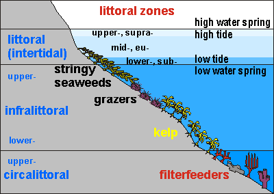 This
diagram shows the general idea behind underwater habitat zoning in northern
New Zealand, but there are differences that apply to the Poor Knights.
For instance, because near the surface, all its shores drop off vertically,
except in a few places. So the intertidal zone is also narrow, except on
its eastern side where waves wet a wide splash zone with barnacles and
encrusting seaweeds.
This
diagram shows the general idea behind underwater habitat zoning in northern
New Zealand, but there are differences that apply to the Poor Knights.
For instance, because near the surface, all its shores drop off vertically,
except in a few places. So the intertidal zone is also narrow, except on
its eastern side where waves wet a wide splash zone with barnacles and
encrusting seaweeds.
 On
truly remote islands like the Kermadec Islands, the influence of seabirds
on the marine environment cannot be overstated. The diagram shows how it
works. Birds nest in their millions on the island, and deposit half of
their meal on the rocks or in their burrows. These bird droppings are extremely
high in nutrients, and should they consolidate and harden, would become
the most sought after guano fertiliser.
On
truly remote islands like the Kermadec Islands, the influence of seabirds
on the marine environment cannot be overstated. The diagram shows how it
works. Birds nest in their millions on the island, and deposit half of
their meal on the rocks or in their burrows. These bird droppings are extremely
high in nutrients, and should they consolidate and harden, would become
the most sought after guano fertiliser.
 .
. The
sand habitat is home to a great variety of organisms, most hidden in between
the sand grains, or burrowed out of sight. Divers will notice that the
sandy areas are never devoid of fishes. On the contrary, one finds quite
a lot going on. Wrasses nip and turn the sand to find morsels of food,
goatfish stir the sand with their barbels, lizardfishes and scorpionfishes
lay there in ambush, hat urchins crawl over it and stingrays come to rest
there, and so on.
The
sand habitat is home to a great variety of organisms, most hidden in between
the sand grains, or burrowed out of sight. Divers will notice that the
sandy areas are never devoid of fishes. On the contrary, one finds quite
a lot going on. Wrasses nip and turn the sand to find morsels of food,
goatfish stir the sand with their barbels, lizardfishes and scorpionfishes
lay there in ambush, hat urchins crawl over it and stingrays come to rest
there, and so on.