Kermadec Islands - a visit to
Raoul By Dr J Floor Anthoni, 2002
www.seafriends.org.nz/issues/res/kermadec/kermvisit.htm
Raoul is a no-take reserve, both above and
under water. A visit to these islands would not be complete without a visit
to Raoul. Here you can read and see what this entails. The Department of
Conservation is tasked with maintaining the historical and natural heritage
of the island, which at times brings conflicts. For instance, rats are
clearly unnatural here and they cause irreparable damage to wildlife. So
they must be exterminated. But what about the stately norfolk pines planted
there by early settlers? Although these do not belong there naturally,
they nonetheless form part of the historical heritage, and cause no harm.
.
Note! for best printed results, set your page up with
a left margin of 1.5cm (0.6") and right margin of 1.0cm (0.4")
For corrections, suggestions and improvements, e-mail
me.
-- home -- issues
index -- marine reserves index -- site
map --
Rev:20020705,20020719,
A visit to Raoul
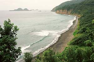
The Kermadecs are a nature no-take reserve, both above and under water.
Although their seas can be plied without a permit, landing on Raoul is
not possible without one. The reasons are obvious, once one considers the
massive impact a few alien seeds can have or a pregnant rat. Once these
islands were the home to myriad sea birds and some land birds, and now
the New Zealand people are determined to return these islands to the condition
they once were.
A permit for
landing can be arranged in advance with the Department of Conservation
(Warkworth branch, NZ), or locally by VHF channel 16. It must be remembered
that a landing is granted only when it does not disturb the daily work,
or cause undue distraction for the resident staff. DoC is interested in
some public relations, showing strangers what they do and why, in order
to win support for conservation in general, and that of the Kermadecs in
particular. Bring your passport to have it stamped, as proof and memento
of your visit.
Here are some of the conditions associated with a landing:
At least one person, capable of handling the boat, must remain on board.
It has happened once, that a boat slipped its anchor warp, and came to
grief on Raoul's shore. Such disasters could release rats and cats on land.
People making the landing by dinghy, should all wear life jackets, however
short and safe the trip.
Footwear should be inspected for attached mud and seeds, in order to prevent
the introduction of alien weeds.
Any bags should be left unopened until inside a building, where any escaping
rodent or insect could be caught.
Visitors cannot wander around by themselves, and they are accompanied by
a DoC officer at all time.
No items, dead or alive, can be removed from the island.
Because a picture speaks a thousand words, a typical visit to Raoul is
illustrated with a number of photos.
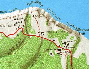
This
map is a detail of the topographical map of Raoul Island, available from
stores and the Internet. It shows the built-up area around Fleetwood Bluff,
a raised platform with two lower flats on its sides. To the east, Low Flat
and to its west, Bells Flat with the air strip. From east to west, one
encounters the Hostel, with accommodation for volunteers, with maintenance
buildings on the other side of the road. The air space is occupied by short-wave
radio antennas. Further down the road is the Meteorological Station with
the Balloon Hut on a clearing above the cliffs. From here one sends weather
balloons up, to measure atmospheric conditions in this very scarcely populated
extent of our planet. The hydrogen lifting gas is made from reacting aluminium
with caustic soda. The road continues over a bridge across Bells Ravine
which cuts steeply through the loose tephra constituting this high flat.
On the other side one finds a cottage built on the place where once the
Bell's cottage stood, in the shelter of the twelve century-old Norfolk
pines. The road continues to the air strip, which is now mainly used as
drop-off zone for parcels delivered by Air Force planes.
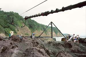
f214515: A landing party has arrived on Fishing Rock, welcomed
by DoC officers. This party also brought the mail from mainland New Zealand,
which is being loaded into a bag under the flying fox. Its sturdy
cable disappears to a spot located above the cliffs. The other steel structure
is a derrick (crane) to lift the DoC surveillance boat from its rails into
the sea. It can also be used to lift goods from boats onto land.
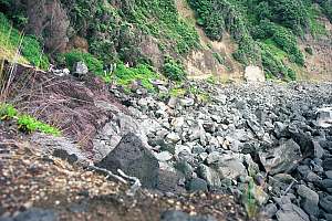
f214518: A goat track leads along the base of the cliffs
to a narrow ravine, and up its side to the landing platform. The coast
here is strewn with broken boulders which desintegrate long before they
can be polished into round stones. Notice the landing party walking on
the track.
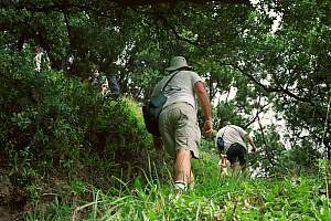
f214520: The goat track leads from the shore to the landing
platform above, gradually revealing the native flora inside the dense Pohutukawa
forest. In the foreground introduced grasses and pasture weeds.
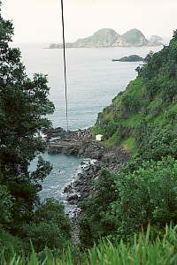
From the landing platform, one can get a view of Fishing
Rock and Meyer Island in the distance, and Egeria Rock nearby. In the far
distance, South Chanter Island can be seen. In the foreground introduced
cuttygrass.
In the white boat shed (right photo), an 'all weather'
boat is kept for emergency evacuation.
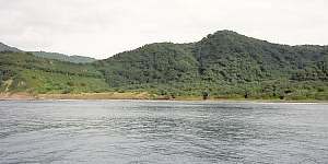
f214605: View of Fishing Rock and flying fox.
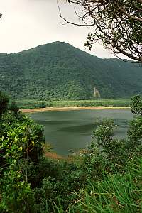
f214525: Blue Lake
As the well maintained dirt road winds over the narrow crater
rim, the Blue Lake, largest of the crater lakes, becomes visible. Once
blue in colour, it is now brown, and its water is not safe for drinking.
Grey ducks are found grazing there.
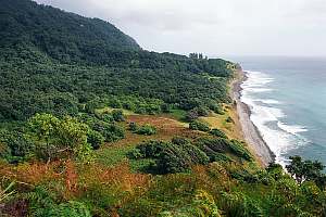
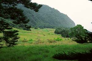
f214526 (above): Where the crater rim leaves the coast,
a view opens of the Low Flat, once covered entirely in grass and grazed
by cattle and sheep. Abandoned since 1910, this area is now reverting back
to native Pohutukawa forest. The brown patches are covered in introduced
bracken fern, seen in detail in the foreground.
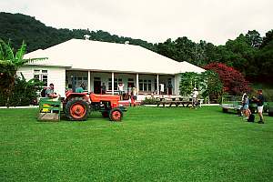
f214527: The strange convoy arrives at the Hostel, where
a welcoming tea party has been prepared in the local kitchen. The vehicles
most popular here are: 4-wheel drive tractor, 4WD quad bike, and similar.
The lawns have been mowed with meticulous care, and fruiting trees, some
of which a century old, are still being harvested.
f214530: A view from the Flagstaff at Fleetwood Bluff (Matatirohia),
back to Fishing Rock. This is North Beach (Oneraki Beach), with hot springs
where its colour changes, on the far end. On right the Low Flat and in
the distance Meyer and Chanter islands.
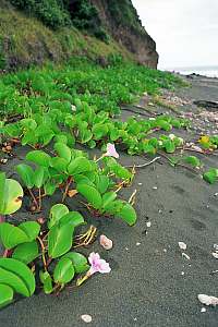
f214533: A tropical beach convolvulus, trapping sand at the
foot of the cliff.
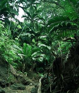
f214535: Nikau palms in Bell's Ravine. It is quite an attractive
short walk from the living compound, to Low Flat, and over the beach back
through Bell's Ravine, where a beautiful stand of the local species of
nikau palm is found.
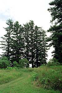
f214536: Century-old Norfolk pines.
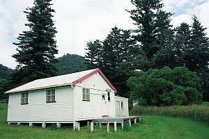
f214601: A cottage stands where once Bell's cottage stood,
in the shelter of the large century old Norfolk pines, with good views
of the surrounding sea. This was necessary in order to hail passing ships
with a smoking fire. From here also the extensive Bell's Flats to the west
can be seen (not shown).
f214603: A view of the landing strip from underneath the
Norfolk pines. This lawn was once maintained effortlessly by sheep and
cattle, but now needs extensive motor mowing. It is mainly used as a drop
zone, because very few air planes are capable of landing here and taking
off. The large foliage on the fields is taro root from the Pacific Islands.
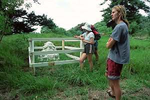
f214602: Mementoes of the history of the island can be found
here and there. DoC is not only entrusted with the conservation of our
natural heritage, but also of our cultural heritage. Here is the grave
of Charles 'Chas' Parker, who died of blood poisoning in 1926.
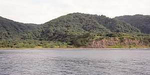
The views below were obtained while sailing from west to east along
the track followed above.
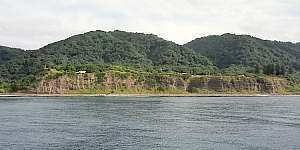
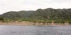
f214633: View of the Low Flat, with the crater rim on left.
f214634: Where the shore line rises, starts Fleetwood Bluff,
with the Flagstaff immediately on the first knoll.
f214635: The various buildings on Fleetwood Bluff become
visible: the Hostel, the Met Station and Balloon Hut. On right the Norfolk
pines.
f214636: Bell's Flats with the landing strip are much higher
than Low Flats. On left the Norfolk pines.
 A permit for
landing can be arranged in advance with the Department of Conservation
(Warkworth branch, NZ), or locally by VHF channel 16. It must be remembered
that a landing is granted only when it does not disturb the daily work,
or cause undue distraction for the resident staff. DoC is interested in
some public relations, showing strangers what they do and why, in order
to win support for conservation in general, and that of the Kermadecs in
particular. Bring your passport to have it stamped, as proof and memento
of your visit.
A permit for
landing can be arranged in advance with the Department of Conservation
(Warkworth branch, NZ), or locally by VHF channel 16. It must be remembered
that a landing is granted only when it does not disturb the daily work,
or cause undue distraction for the resident staff. DoC is interested in
some public relations, showing strangers what they do and why, in order
to win support for conservation in general, and that of the Kermadecs in
particular. Bring your passport to have it stamped, as proof and memento
of your visit.
 This
map is a detail of the topographical map of Raoul Island, available from
stores and the Internet. It shows the built-up area around Fleetwood Bluff,
a raised platform with two lower flats on its sides. To the east, Low Flat
and to its west, Bells Flat with the air strip. From east to west, one
encounters the Hostel, with accommodation for volunteers, with maintenance
buildings on the other side of the road. The air space is occupied by short-wave
radio antennas. Further down the road is the Meteorological Station with
the Balloon Hut on a clearing above the cliffs. From here one sends weather
balloons up, to measure atmospheric conditions in this very scarcely populated
extent of our planet. The hydrogen lifting gas is made from reacting aluminium
with caustic soda. The road continues over a bridge across Bells Ravine
which cuts steeply through the loose tephra constituting this high flat.
On the other side one finds a cottage built on the place where once the
Bell's cottage stood, in the shelter of the twelve century-old Norfolk
pines. The road continues to the air strip, which is now mainly used as
drop-off zone for parcels delivered by Air Force planes.
This
map is a detail of the topographical map of Raoul Island, available from
stores and the Internet. It shows the built-up area around Fleetwood Bluff,
a raised platform with two lower flats on its sides. To the east, Low Flat
and to its west, Bells Flat with the air strip. From east to west, one
encounters the Hostel, with accommodation for volunteers, with maintenance
buildings on the other side of the road. The air space is occupied by short-wave
radio antennas. Further down the road is the Meteorological Station with
the Balloon Hut on a clearing above the cliffs. From here one sends weather
balloons up, to measure atmospheric conditions in this very scarcely populated
extent of our planet. The hydrogen lifting gas is made from reacting aluminium
with caustic soda. The road continues over a bridge across Bells Ravine
which cuts steeply through the loose tephra constituting this high flat.
On the other side one finds a cottage built on the place where once the
Bell's cottage stood, in the shelter of the twelve century-old Norfolk
pines. The road continues to the air strip, which is now mainly used as
drop-off zone for parcels delivered by Air Force planes.