By Dr J Floor Anthoni, 2002
www.seafriends.org.nz/issues/res/kermadec/kermgeo.htm
The Kermadec Islands consist of 13 islands
and islets, located between 800km and 1000km north-east of New Zealand.
Macauley and Raoul account for over 95% of the land. This chapter examines
their origins. The islands are volcanoes of the Kermadec Ridge, pushed
up by the Pacific Plate which subducts into the deep Kermadec Trench.
The geology of (submarine) volcanoes and a geologic description of
each of the islands, Raoul, Macauley,
Curtis
& Cheeseman and Esperance. (on this page)
For charts of the islands, visit the chapter on dive
sites.
Topographical map, as can be obtained from the Department of Land Information
NZ (LINZ). Homepage: www.linz.govt.nz Detailed (1:25,000) topographical
map of Raoul (free, 2MB): http://ortho.linz.govt.nz/nz_offshore_islands/raoul_high_res.jpg.
Also some photographs of the island.
Note! for best printed results, set your page up with
a left margin of 1.5cm (0.6") and right margin of 1.0cm (0.4")
For corrections, suggestions and improvements, e-mail
me.
-- home -- issues
index -- marine reserves index -- Kermadecs
index -- site map --
Rev:20020719,
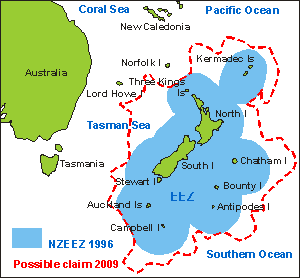
Location
This
map shows New Zealand in relation to Australia. It also shows NZ's outlying
islands and its Exclusive Economic Zone (EEZ). The Kermadec islands lie
NE of New Zealand, roughly in the direction of NZ's main axis. Their distances
apart and their distance to the North Island happen to be of the right
size to add a considerable area of EEZ. As can be seen, Norfolk Island
which is administered by Australia, lies roughly at the same latitude of
about 30ºS.
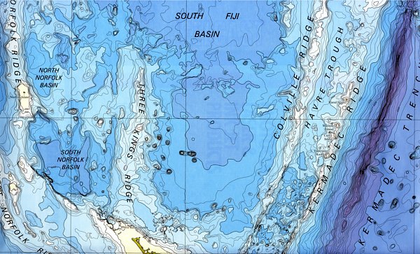
The detailed map of the sea bottom, shown below (Map courtesy NIWA)
reveals that the sea bottom has major features such as the 8km deep Kermadec
Trench on right, and west of it the Kermadec Ridge, which provides the
volcanic activity to bring the Kermadec Islands to the surface. further
west the Colville Ridge, which is of older date. In the middle the South
Fiji Basin, a large area of deep ocean floor of 3-4km deep. To the left
the Three Kings Ridge, also formed much earlier than the others, and finally
the Norfolk Ridge with the submarine volcano of Norfolk Island, which has
a very large plateau on it. At the very bottom of the chart, the northern
tip of the North Island can be seen.
Please take note of the location of the Kermadecs, in order to locate
it at world maps used further down this chapter (and the chapter on ecology),
on which they are not marked.
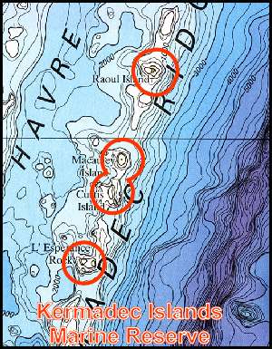
Kermadec
Islands Marine Reserve The marine reserve created around the Kermadec Islands consists essentially
of four circles of 12 nautical miles (22km) radius, centred around every
outcrop, amounting to three disjoined areas adding up to 7480km2,
but separated by gaps of 15-25 km. As can be seen from the map, most of
the marine reserve consists of blue ocean to a depth of 1000m and some
of it even to 2000m. Most of the sea bottom is found deeper than 500m,
out of reach of daylight.
The main habitat it protects is thus blue ocean with very little life,
and a muddy sea bottom, as dark as the night, with here and there a rocky
outcrop with filterfeeders attached. How much of it is there and what it
looks like, is not known, because it is still being investigated.
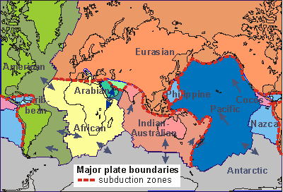
Tectonic plates
On
the world map of tectonic plates, one can see that an important subduction
zone between the Indian-Australian plate and the Pacific plate, runs through
the Kermadecs and through the main axis of NZ. These two plates mainly
slide past each other, which makes the subduction component weak. As the
Pacific plate slides below the other, it pushes the other margin up, resulting
in a ridge. The melting plate which is drawn down, causes volcanic activity
in the area of the ridge, rising from about 100km depth, resulting in volcanoes
rising up above the ridge. Such volcanoes formed the islands of the Kermadec
Group. Subduction zones are usually found where ocean plates meet continents,
as the map shows, and the situation of one ocean plate subsiding underneath
another ocean plate is uncommon. The two plates move relatively to one
another at the speed of 7cm per year, which is relatively fast for such
a process.
The
diagram shown here (courtesy Institute of Geological and Nuclear Sciences),
illustrates to scale the extent to which the Pacific Plate is subducted.
From the locations of deep earthquakes, it is concluded that the plate
is drawn down to a depth of over 600km. But shallower, at around 100km,
very hot magma is formed, which is pushed upward through cracks in the
Australian Plate, forming volcanism. Rising heat also buckles up the crust
to form the Havre Trough.
This volcanic area is closely monitored because eruptions could be
hazardous to passing ships and overflying aircraft. Jet engines are extremely
sensitive to volcanic ash. Serious submarine slumps could also threaten
New Zealand with a tsunami - dangerous because of its short warning time
(1-2hours) and close proximity.
Geology
All the islands in the Kermadec Group have been formed by volcanic eruptions.
Usually the first phase of a volcano starts with violence and the release
of trapped gases under very high pressure. As the liquid rock is blasted
into the air, the dissolved gases expand, pulverising the rock to ash,
pumice and scoria, most of it falling down on the volcanic cone (tephra).
Such cones are thus built up from layers of tephra, and the volcano is
called a stratovolcano (stratum=layer). As the volcano grows older,
its activity diminishes and its eruptions become less violent. Eventually
it may just ooze liquid lava, forming a cap on the cone (shield volcano).
When a submarine volcano reaches the surface, its cone becomes subjected
to heavy erosion by waves, most tephra being worn away as fast as it is
laid down. A large flat top may remain, with protruding cores of rock,
which once were crater plugs. Deeper than 100m, the action of waves is
no longer felt, and their erosion negligible. While a submarine volcano
remains under water, the ash cannot travel far, and all tephra lands on
the cone, building the volcano fast and steep.
During the last ice age, when the ocean level was about 120m lower than
today, the islands must have been much larger. Ironically, both Curtis
and Macauley are volcanoes with very flat tops at 120m depth, and they
may have been as large or larger in area than Raoul at the time. Now these
gently sloping flatlands lie just within reach of daylight, hosting fish
life much richer than that found deeper down.
The outlying Meyer and Herald Islands were formed from underwater eruptions,
0.5-1.5 million years ago.
Stratovolcano: (L: stratum=layer) These
are steep volcanic cones built by both pyroclastic (thrown by fire)
and lava-flow eruptions. They are composed of volcanic rock types that
vary from basalt to rhyolite, but their composition is generally
andesite.
Stratovolcanoes may erupt many thousands of times over life spans of millions
of years. A typical eruption would begin with ash explosions and end with
extrusion of thick viscous lava flows. The cone-shaped form begins gradually
and becomes steeper (up to 35°) toward the summit, which generally
contains a crater.
Tephra: (Gk: tephra= ash) loose material,
e.g. ash and pumice, deposited by volcanic eruptions.
Dacite: An extrusive igneous rock in composition
between rhyolite and andesite, consisting mainly of the minerals feldspar
and quartz.
Tholeiite basalt: A basalt resembling that found
in Tholey, Germany.
See also the geology
glossary on this web site. Right-click on this link and open it in
a new window for ease of reference.
Raoul Raoul is a stratovolcano, composed of material ejected from several
eruption centres, mostly andesitic tuffs. The Herald Islets were the first
to be active, and the Denham Bay crater is estimated at 2100 years of age.
Raoul erupted 14 times above water. What happened before, is not known.
From 1800-1995 eruptions happened simultaneously from both calderas. The
last eruption happened on 21 November 1964, forming 12 small craters in
the caldera, while ejecting clouds of ash. In 1965 another eruption happened,
and in 1994 earth shocks only.
Located around 29.27S, 177.92W. Raoul measures 29.25km2 (2925Ha), which
is slightly smaller than Norfolk Island (no longer volcanically active),
which measures 34km2 (3400Ha). Mount Moumoukai is Raoul's largest mountain,
rising to 516m. The island has two lakes and a freshwater lagoon at Denham
Beach. Its caldera (crater) is 3.3km wide, and there is a second crater
in the rim of cliffs. A third crater is found in Denham Bay.
For charts, visit the chapter on diving.
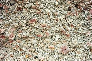
f214519: The crumbly structure of the rock, close to the
foot of a cliff, is made up of porous scoria, pumice and ash.
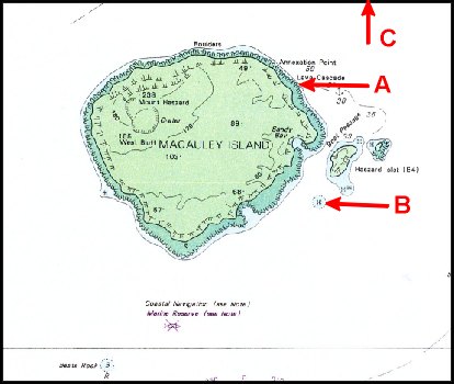
Macauley (chart) Macauley is quite a substantial volcano, standing on a base over 900m
deep, where it measures 380km2. Built from tholeiite basalt and interbedded
dacite tephra, the island measures about 3.1km2. Continued eruption of
thin basalt flows built a large shield volcano with a smooth but hard top
at 150m high, where a small crater can be found.
Only a few thousand years ago, a large eruption of dacite tephra (Sandy
Bay tephra) caused the collapse of the flanks of the submarine volcano
to form a caldera immediately NW of the island. The magnitude of this eruption
was larger than Mt Krakatoa and comparable with that of Lake Taupo. Renewed
basaltic volcanism produced scoria cones, flows and tephra, and the final
stage of this eruptive phase was associated with the collapse of the NW
edge of the island into the caldera, estimated 6300years ago by carbon
dating of Sandy Bay tephra. This caldera lies about 1000m deep. Future
eruptions at Macauley are likely to be submarine, with the danger of a
catastrophic tsunami.
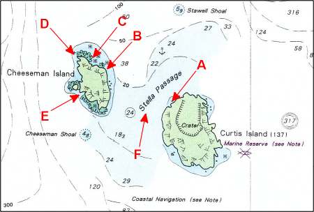
Curtis and Cheeseman (chart) The total land area of Curtis and Cheeseman is about 60 Ha (147 acres).
Curtis remains active with daily earthquakes and small eruptions destroying
the vegetation in its caldera. The islands are the eroded peak of a large
volcano, measuring 25x15km at its base on the Kermadec Ridge. The rocks
of these islands stem from pyroclastic poorly-bedded ash deposits. Curtis
has been rising by 18m in the past 200 years.
l'Esperance Rock Previously known as French Rock, l'Esperance is but a pinnacle rising
up steeply from the surrounding sea floor: 100m directly off the pinnacle,
while its submerged mountain rises from an 800m deep ridge. 250m in diameter,
it measures optimistically 4.8 Ha (12 acres). l'Esperance has no volcanic
activity and has been like that for many thousands of years.
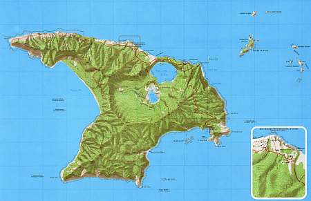
Topographical map and photos The
topographical map of Raoul shown here is part of the map which is freely
available from the LINZ web site. The inset shows the location of the buildings,
and it covers the most inhabited part of the island. The map shows graphically
that Raoul is completely covered in forest, where the steep cliffs are
and the sandy beaches. Best of all, its shading shows the shape of the
crater's deep impression, the caldera. It can now also be seen that Denham
Bay forms another crater, to the west of it.
A large part of the rain falling on Raoul, ends up in the crater lakes,
which are 3-6m above sea level. Excess water drains through the porous
rocks out to sea.
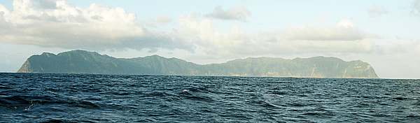
f214504: This is the first view of Raoul, when arriving from
New Zealand, from a SW direction. The typical anvil shape of the island
cannot be discerned. From this angle, most of what one sees on left, is
Denham Bay, with Hutchison Bluff far left. On the far right, d'Arcy Point
and one third left of it, Smith Bluff. The highest point seems to be Hutchison
Ridge (476m), on left, but Mt Moumoukai (516m), lies in the far back, one
third from right.
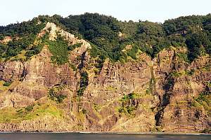
f214702: Most of the island consists of layers of tephra,
compressed to soft rock. It wears away rapidly in some places, as shown
here. Notice how some layers are thick, and others narrow, waving up and
down with the shapes of the valleys.
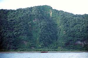
f214703: The cliffs around Denham Bay are old, and well covered
in native forest. Here and there a slip or rock fall shows. These cliffs
are not under threat from the sea because of the beach and low flats sheltering
them from the waves. In the middle of the photo the wreck of the Japanese
fishing boat Kino Maru 2.
 This
map shows New Zealand in relation to Australia. It also shows NZ's outlying
islands and its Exclusive Economic Zone (EEZ). The Kermadec islands lie
NE of New Zealand, roughly in the direction of NZ's main axis. Their distances
apart and their distance to the North Island happen to be of the right
size to add a considerable area of EEZ. As can be seen, Norfolk Island
which is administered by Australia, lies roughly at the same latitude of
about 30ºS.
This
map shows New Zealand in relation to Australia. It also shows NZ's outlying
islands and its Exclusive Economic Zone (EEZ). The Kermadec islands lie
NE of New Zealand, roughly in the direction of NZ's main axis. Their distances
apart and their distance to the North Island happen to be of the right
size to add a considerable area of EEZ. As can be seen, Norfolk Island
which is administered by Australia, lies roughly at the same latitude of
about 30ºS.
 Kermadec
Islands Marine Reserve
Kermadec
Islands Marine Reserve
 On
the world map of tectonic plates, one can see that an important subduction
zone between the Indian-Australian plate and the Pacific plate, runs through
the Kermadecs and through the main axis of NZ. These two plates mainly
slide past each other, which makes the subduction component weak. As the
Pacific plate slides below the other, it pushes the other margin up, resulting
in a ridge. The melting plate which is drawn down, causes volcanic activity
in the area of the ridge, rising from about 100km depth, resulting in volcanoes
rising up above the ridge. Such volcanoes formed the islands of the Kermadec
Group. Subduction zones are usually found where ocean plates meet continents,
as the map shows, and the situation of one ocean plate subsiding underneath
another ocean plate is uncommon. The two plates move relatively to one
another at the speed of 7cm per year, which is relatively fast for such
a process.
On
the world map of tectonic plates, one can see that an important subduction
zone between the Indian-Australian plate and the Pacific plate, runs through
the Kermadecs and through the main axis of NZ. These two plates mainly
slide past each other, which makes the subduction component weak. As the
Pacific plate slides below the other, it pushes the other margin up, resulting
in a ridge. The melting plate which is drawn down, causes volcanic activity
in the area of the ridge, rising from about 100km depth, resulting in volcanoes
rising up above the ridge. Such volcanoes formed the islands of the Kermadec
Group. Subduction zones are usually found where ocean plates meet continents,
as the map shows, and the situation of one ocean plate subsiding underneath
another ocean plate is uncommon. The two plates move relatively to one
another at the speed of 7cm per year, which is relatively fast for such
a process.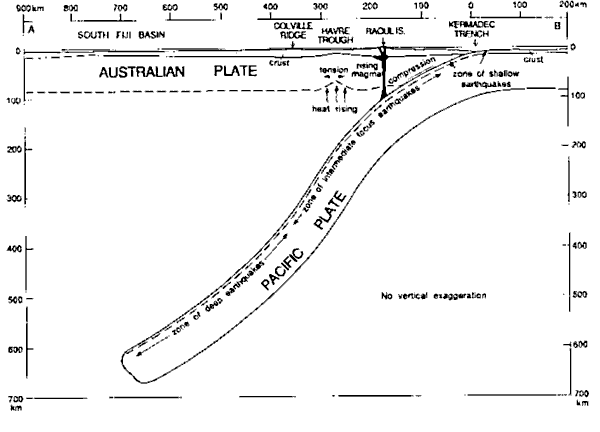 The
diagram shown here (courtesy Institute of Geological and Nuclear Sciences),
illustrates to scale the extent to which the Pacific Plate is subducted.
From the locations of deep earthquakes, it is concluded that the plate
is drawn down to a depth of over 600km. But shallower, at around 100km,
very hot magma is formed, which is pushed upward through cracks in the
Australian Plate, forming volcanism. Rising heat also buckles up the crust
to form the Havre Trough.
The
diagram shown here (courtesy Institute of Geological and Nuclear Sciences),
illustrates to scale the extent to which the Pacific Plate is subducted.
From the locations of deep earthquakes, it is concluded that the plate
is drawn down to a depth of over 600km. But shallower, at around 100km,
very hot magma is formed, which is pushed upward through cracks in the
Australian Plate, forming volcanism. Rising heat also buckles up the crust
to form the Havre Trough.
 The
topographical map of Raoul shown here is part of the map which is freely
available from the LINZ web site. The inset shows the location of the buildings,
and it covers the most inhabited part of the island. The map shows graphically
that Raoul is completely covered in forest, where the steep cliffs are
and the sandy beaches. Best of all, its shading shows the shape of the
crater's deep impression, the caldera. It can now also be seen that Denham
Bay forms another crater, to the west of it.
The
topographical map of Raoul shown here is part of the map which is freely
available from the LINZ web site. The inset shows the location of the buildings,
and it covers the most inhabited part of the island. The map shows graphically
that Raoul is completely covered in forest, where the steep cliffs are
and the sandy beaches. Best of all, its shading shows the shape of the
crater's deep impression, the caldera. It can now also be seen that Denham
Bay forms another crater, to the west of it.