| Introduction to this section and general dive information. (on this page) | ||
| Diving around the most fascinating island, Raoul. (on this page) | ||
| Diving around Macauley. (on this page) | ||
| Diving around Curtis and Cheeseman islands. (on this page) | ||
| Diving l'Esperance rock. (on this page) | ||
|
Links
|
Links to information on the Internet. (below)
|
Note! for best printed results, set your page up with
a left margin of 1.5cm (0.6") and right margin of 1.0cm (0.4")
For corrections, suggestions and improvements, e-mail
me. I am most interested to include more dive spots and experiences of
others here.
-- home -- issues
index -- marine reserves index -- Kermadecs
index -- site map --
Rev:20020719,20070530,
| Introduction
Although located only 1000km (Raoul) NE from Auckland in New Zealand, the Kermadec Islands are difficult to reach. An expedition of two weeks may give only 3 days of diving. One day is well spent visiting Raoul, which can be arranged by VHF radio channel 16 [see box]. Raoul has a 'permanent' Department of Conservation staff of four, who do a full year's service, and more volunteers for about 8 months a year. Here one can experience the work of conservation volunteers, their enthusiasm, hospitality and determination, from nearby. |
| Arranging for a landing permit
As of May 2007, DOC has changed the way landing permits are issued. Since the island is now completely free from rats, achieved at very high cost and effort, it is feared that ships can too easily re-introduce rats to the island. Karen Baird, Programme Manager Raoul Island, has this to say: As you are aware all the Kermadec group are now pest free. As a result of this status we are keen to increase the biosecurity provisions to ensure that this status is maintained. In achieve this we would like to ensure that all yachties departing for Raoul with the intention of stopping off should obtain permits prior to leaving NZ. This will enable us to ensure that boats are rodent free and alert our staff on the island of likely arrival times so that they can ensure that rat bait stations and traps are set in advance. It may also be worth noting in your web site that all boaties who intend even stopping off even without landing should make sure that their boats contain rat prevention measures as even anchoring close to the islands can pose a risk. Direct dial 09 4257243 Mobile 027 4910708 Please note that the information in this box is subject to change. Contact DoC direct. |
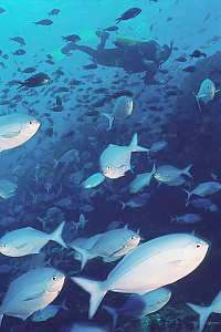
The voyage of 1000km takes most boats 4-5 days each way, but once within the Kermadec Group, dives can be planned along the way, off the islands l'Esperance, Curtis & Cheeseman, and Macauley. Remarkable of this trip is the vast extent of deep blue water with a clarity of over 30m visibility. Not much life is found in this barren stretch of ocean. But close to the islands, the water colour changes somewhat, and visibility drops to 30m, which is still excellent. The water is warmer too, and by a noticeable 3-4ºC. A 5mm wetsuit or unisuit is more than adequate.
After the sperm whale whaling stopped, the Kermadecs have been avoided by ships, as a potential navigation hazard in an otherwise vacant ocean. But once a year sailing boats leave NZ for the tropical islands of the Tonga group and further, in the months March to May, after the hurricane season, often visiting Raoul for a welcome break. A dive trip is best planned inside this window of time.
Being such tiny specks of land in a wide ocean, one would not have expected sea currents there, but the large and slow tide wave, encircling NZ twice daily, hits the Kermadec ridge head-on, causing strong N-S currents, which are unpredictable in their timing. Be aware of this, and keep a good eye on the rhythm of these currents, planning your dives accordingly.
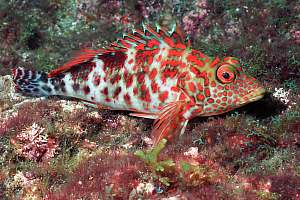
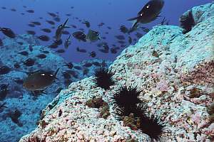
Many sharks are encountered during dives, especially during shallow dives. These are most likely Galapagos sharks (Carcharhinus galapagensis), which are inquisitive but harmless.However, watch out when they begin to group together.
A small pod of very shy bottlenose dolphins, one of which has its dorsal fin cut off, can be encountered.
Underwater photography is benefited by the clarity of the water, but the swell may suspend tiny bubbles from the surface down to 10m, and whirl light pumice sand up from the botom. Holding the camera still, is often a problem. The drag of currents on voluminous cameras could also be a problem. Both the clear water, and being 7 degrees of latitude closer to the sun, make for better light conditions.
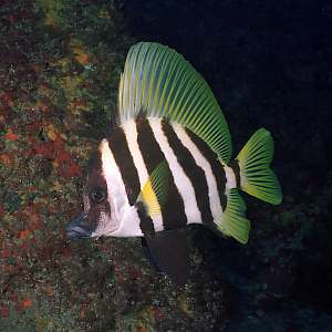
It may sound superfluous, but please remember that these islands are all protected, both above and under water. This means that no harm must be inflicted on any creatures. Please remember that the Kermadecs are a fragile ecosystem, which can not sustain much interference. Make sure that generations of divers after you will still enjoy meeting the same creatures you saw.
Should you have additional dive information, please e-mail
me with the facts, such that they can be fitted in with the ones shown
here. Also please provide extra information and verification of the sites
listed here.
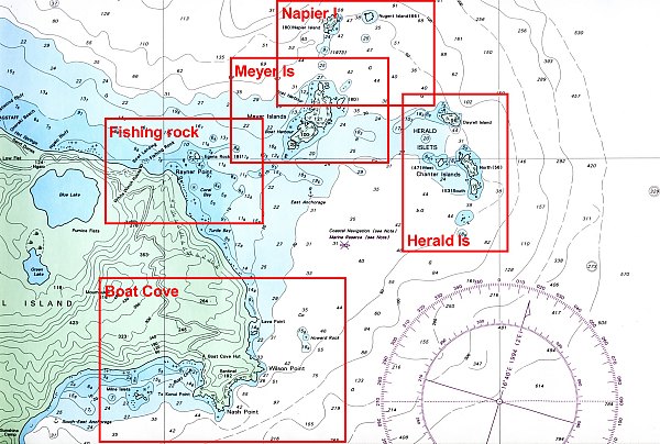
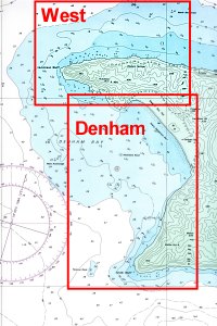
| Raoul
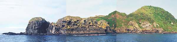
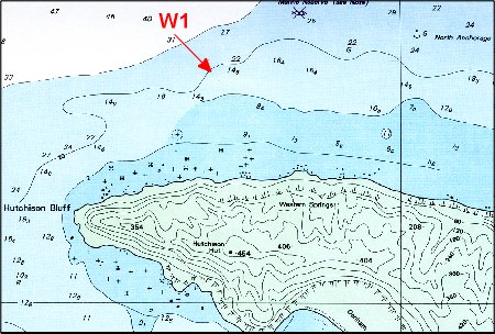
Raoul is the main island in the group and has the largest area of shallow underwater habitat. It is also the northernmost island, and for those two reasons, has the most varied underwater life of the Kermadec Group. Raoul itself consists mainly of soft tephra, of compressed scoria, pumice and ash. In many places, the coast erodes so fast that trees do not have enough time to settle. |
Outside the tropical cyclone season, the prevailing winds come from
the SW, the heavy swell of which developed over a thousand km of ocean.
It bends around Raoul, which is of the right size to do so, and they often
pound in on Boat Cove, in the Boat Cove rectangle. Generally the most sheltered
diving
is found West of Meyer Island. The dive spots will be discussed as they
occur on the detailed charts.
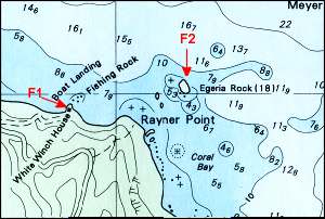 Fishing
Rock area Fishing
Rock area
|
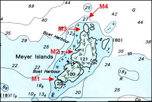 Meyer
Island area Meyer
Island area
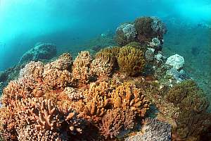
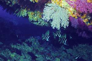
The western side of Meyer Island is usually sheltered, and fortunately provides for excellent diving and snorkelling along its entire coastline. The shore has broken rocks and gullies, which provides for a variety of corals and fishes. Down from 6m, the rocks slope ever more gently down to a bottom of over 20m, where it is good anchoring.Make sure you plan some night dives too!
|
 |
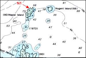 Napier
and Nugent islands Napier
and Nugent islands
Both Napier and Nugent Islands are placed across the 50m isobath, having steep drop-offs on their outer sides, which are also their sunlit sides. Their sides turned away from the sun (southerly sides) should show colourful gorgonians at relatively shallow depth.
|
 |
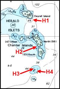 Herald
Islets and Chanter Herald
Islets and Chanter
Like Napier Island, the Herald Islets and Chanter are also located on the 50m depth contour, with shallow diving on their western sides and deep diving on their eastern sides. The little arc of islands may sometimes protect against wind and chop from the NE, providing for excellent diving.
|
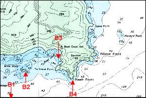 Diving
around Boat Cove Diving
around Boat Cove
Boat Cove on Raoul's SE side, provides good shelter and access to the island when waves and weather come in from the NW. It is good anchoring on the flat sandy/gravelly bottom at 17m depth. This side of the island is turned away from the sun, and the rock walls miss the characteristic corals of Meyer Island.
|
 |
 |
Diving the western side of Raoul
|
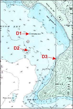
Denham Bay Denham Bay essentially consists of a large sandy flat around a crater.
|
| Macauley Island
Macauley is a large undersea volcano with a very flat top(far beyond diving depth), of which Macauley Island protrudes out of the water. The top of this island looks flat and rounded from all sides, but a crater is found near its highest point, Mt Haszard. Although initially a stratovolcano (layered with soft material), the top has been formed from slow lava flows as a shield volcano. |
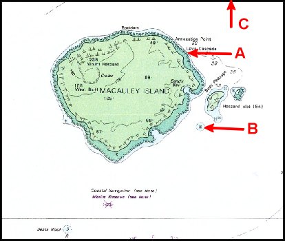 The
entire island is surrounded by reasonably hard rock and could be dived
upon. We have a record only from the following sites: The
entire island is surrounded by reasonably hard rock and could be dived
upon. We have a record only from the following sites:
|
 |
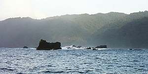
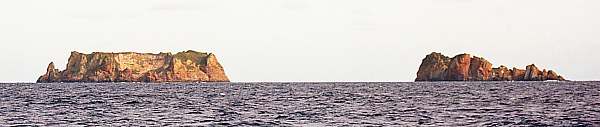
| Curtis and Cheeseman
Curtis is a very wide submarine volcano, rising from a 500m deep sea floor on the Kermadic Ridge. It is still very active, being monitored continually. The main crater lies to the East of the island, still today a deep spot of 317m in surrounding flats of no deeper than 50m. The rocks around Curtis have been spewed out by the crater (tephra), forming soft rock all around the island. These rocks are poorly covered in marine life. |
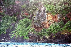
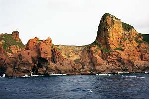
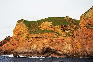
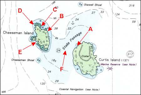 By
contrast, neighbouring Cheeseman Island consists of much harder material,
around which pinnacles and rock platforms (the grey coloured frills around
the island on the chart). Most dive sites are found in this area. Good
anchoring is found by the anchor symbol, where the bottom consists of loose
grey sand. Anchoring is also possible in the entire Stella Passage, where
the bottom consists of mixed gravel and sand. By
contrast, neighbouring Cheeseman Island consists of much harder material,
around which pinnacles and rock platforms (the grey coloured frills around
the island on the chart). Most dive sites are found in this area. Good
anchoring is found by the anchor symbol, where the bottom consists of loose
grey sand. Anchoring is also possible in the entire Stella Passage, where
the bottom consists of mixed gravel and sand.
|
 |
 |
 |
| l'Esperance Rock
l'Esperance Rock is a very small pinnacle, formed of hard basalt, rising steeply from a 100m deep bottom. It acts like a Fish Aggregation Device (FAD), attracting pelagic species. Many divers have reported this as their most spectacular dive, but in the past five years, fish life appears to have diminished considerably. Among the pelagics found here, are grey nurse sharks and bronze whaler sharks. Due to large swell, curving all around the rock, diving is not always possible. Anchoring is a problem too. (No photos or map) |